Back to Show me around

The 30-second version

Checked September 6, 2026

Hours
Plan on gates 8am to sunset. The 2026 operating order: no entry after sunset, all areas close 45 minutes after sunset until 8am, and vehicles and bikes should head out within 15 minutes. Approved after-hours events are the exception.
parks.ca.gov
Dogs
Pets are prohibited on trails and fire roads; trained service dogs are allowed on leash. Developed-area rules differ.
parks.ca.gov
Bikes
Road-width dirt and gravel fire roads and specifically designated singletrack, Class 1 e-bikes included. Check the park map and signs before riding other segments.
parks.ca.gov
Horses
Check the park map and signs for horseback-riding permissions on your route.
parks.ca.gov
Fees
A vehicle entry fee is charged at the staging areas and gates and differs by access point. Check current amounts on the park page.
parks.ca.gov

Facilities

Mitchell Canyon Visitor Center

At the Mitchell Canyon Staging Area, 96 Mitchell Canyon Road, Clayton. Published hours are weekends and some holidays 8am–4pm; staffing should be verified.

Summit Visitor Center

Atop the mountain's highest peak. The park lists exhibits on the mountain's natural and cultural history, a gift shop and an observation deck. Published hours are daily 10am–4pm; staffing should be verified.

Getting in

Mitchell Canyon Staging Area · At Clayton's edge

Where
96 Mitchell Canyon Road, Clayton, CA 94517
Parking
Designated staging area with a published vehicle entry fee, paid by cash or check as published; confirm current payment methods.
Hours
Park gate 8am to sunset.
Facilities
MDIA lists water and toilets. Bring water and check current facilities before going.

There is no vehicle route to the summit from here.

Routes from here: Mitchell Canyon nature walk, Twin Peaks–Mitchell Rock loop, Black Point loop, Mitchell Canyon–Back Creek loop, Mitchell Canyon to Mount Diablo summit loop, Falls loop from Mitchell Canyon, Olofson Ridge, Eagle Peak loop from Mitchell Canyon

Plan Mitchell Canyon access

Regency Drive Trailhead · At Clayton's edge

Where
End of Regency Drive, Clayton (no numeric address verified)
Parking
Only in designated street areas; parts of Regency Drive prohibit parking, and school parking is not overflow. Current street signs control.
Hours
State park operating hours apply inside the boundary.

Routes from here: Donner Canyon–Falls loop from Regency, Mount Olympia loop via Middle Trail

Check access and route context

Lower Summit Parking Lot · Nearby

Where
Summit area; the trailhead is above the lot at the end of the one-way descending summit road
Parking
Reached by the park's summit road, not by driving through Mitchell Canyon.
Hours
State park rules; approved astronomy programs may have specific after-hours arrangements.
Facilities
MDIA lists water and toilets. Bring water and check current facilities before going.

Routes from here: Mary Bowerman summit circuit

See the summit trailhead description

Hikes described by the guides

Routes as published by the Mount Diablo Interpretive Association and Save Mount Diablo. Figures are theirs and approximate; the park sets the rules.

  • EasyMount Diablo hike · Mount Diablo Interpretive Association

    Mitchell Canyon nature walk

    Starts at Mitchell Canyon Staging Area~4 mi500 ft gainOut and back

    Before you hike

    Distance and difficulty are from Mount Diablo Interpretive Association; distances are approximate.

    Starts at
    Mitchell Canyon Staging Area
    Access
    96 Mitchell Canyon Road, Clayton, CA 94517
    Posted hours
    Park gate 8am to sunset.
    Parking
    Designated staging area with a published vehicle entry fee, paid by cash or check as published; confirm current payment methods.
    Facilities
    MDIA lists water and toilets. Bring water and check current facilities before going.

    There is no vehicle route to the summit from here.

    Route information checked Sep 2026. Access information checked Sep 2026. Check the park for current rules and closures.

    Worth knowing

    The distance is for MDIA's standard turnaround; the optional Globe Lily return is a separate variant.

    Use the linked guide and current official map for navigation; this outline does not give turn-by-turn directions.

    Open full page

    Check the park page for current closures, including fire closures, before going.

  • ModerateMount Diablo hike · Mount Diablo Interpretive Association

    Twin Peaks–Mitchell Rock loop

    Starts at Mitchell Canyon Staging Area~4 mi1,100 ft gainLoop

    Before you hike

    Distance and difficulty are from Mount Diablo Interpretive Association; distances are approximate.

    Starts at
    Mitchell Canyon Staging Area
    Access
    96 Mitchell Canyon Road, Clayton, CA 94517
    Posted hours
    Park gate 8am to sunset.
    Parking
    Designated staging area with a published vehicle entry fee, paid by cash or check as published; confirm current payment methods.
    Facilities
    MDIA lists water and toilets. Bring water and check current facilities before going.

    There is no vehicle route to the summit from here.

    Route information checked Sep 2026. Access information checked Sep 2026. Check the park for current rules and closures.

    Worth knowing

    MDIA warns of vertical drop-offs at Twin Peaks.

    Use the linked guide and current official map for navigation; this outline does not give turn-by-turn directions.

    Open full page

    Check the park page for current closures, including fire closures, before going.

  • ModerateMount Diablo hike · Mount Diablo Interpretive Association

    Black Point loop

    Starts at Mitchell Canyon Staging Area~4.8 mi1,190 ft gainLoop

    Before you hike

    Distance and difficulty are from Mount Diablo Interpretive Association; distances are approximate.

    Starts at
    Mitchell Canyon Staging Area
    Access
    96 Mitchell Canyon Road, Clayton, CA 94517
    Posted hours
    Park gate 8am to sunset.
    Parking
    Designated staging area with a published vehicle entry fee, paid by cash or check as published; confirm current payment methods.
    Facilities
    MDIA lists water and toilets. Bring water and check current facilities before going.

    There is no vehicle route to the summit from here.

    Route information checked Sep 2026. Access information checked Sep 2026. Check the park for current rules and closures.

    Worth knowing

    Save Mount Diablo describes a different, roughly five-mile variant with a summit spur; follow the MDIA guide for this 4.8-mile route.

    Use the linked guide and current official map for navigation; this outline does not give turn-by-turn directions.

    Open full page

    Check the park page for current closures, including fire closures, before going.

  • StrenuousMount Diablo hike · Mount Diablo Interpretive Association

    Mitchell Canyon–Back Creek loop

    Starts at Mitchell Canyon Staging Area~7 mi1,700 ft gainLoop

    Before you hike

    Distance and difficulty are from Mount Diablo Interpretive Association; distances are approximate.

    Starts at
    Mitchell Canyon Staging Area
    Access
    96 Mitchell Canyon Road, Clayton, CA 94517
    Posted hours
    Park gate 8am to sunset.
    Parking
    Designated staging area with a published vehicle entry fee, paid by cash or check as published; confirm current payment methods.
    Facilities
    MDIA lists water and toilets. Bring water and check current facilities before going.

    There is no vehicle route to the summit from here.

    Route information checked Sep 2026. Access information checked Sep 2026. Check the park for current rules and closures.

    Worth knowing

    The guide returns toward the trailhead from Coulter Pine; check the final connector against the current official map.

    Use the linked guide and current official map for navigation; this outline does not give turn-by-turn directions.

    Open full page

    Check the park page for current closures, including fire closures, before going.

  • DemandingMount Diablo hike · Mount Diablo Interpretive Association

    Mitchell Canyon to Mount Diablo summit loop

    Starts at Mitchell Canyon Staging Area~13 mi3,200 ft gainLoop

    Before you hike

    Distance and difficulty are from Mount Diablo Interpretive Association; distances are approximate.

    Starts at
    Mitchell Canyon Staging Area
    Access
    96 Mitchell Canyon Road, Clayton, CA 94517
    Posted hours
    Park gate 8am to sunset.
    Parking
    Designated staging area with a published vehicle entry fee, paid by cash or check as published; confirm current payment methods.
    Facilities
    MDIA lists water and toilets. Bring water and check current facilities before going.

    There is no vehicle route to the summit from here.

    Route information checked Sep 2026. Access information checked Sep 2026. Check the park for current rules and closures.

    Worth knowing

    The summit rock is inside the visitor-center rotunda; interior access is not guaranteed.

    Use the linked guide and current official map for navigation; this outline does not give turn-by-turn directions.

    Open full page

    Check the park page for current closures, including fire closures, before going.

  • ModerateMount Diablo hike · Save Mount Diablo

    Donner Canyon–Falls loop from Regency

    Starts at Regency Drive Trailhead~5.1 miLoop

    Before you hike

    Distance and difficulty are from Save Mount Diablo; distances are approximate.

    Elevation gain was not reported by the guide.

    Starts at
    Regency Drive Trailhead
    Access
    End of Regency Drive, Clayton (no numeric address verified)
    Posted hours
    State park operating hours apply inside the boundary.
    Parking
    Only in designated street areas; parts of Regency Drive prohibit parking, and school parking is not overflow. Current street signs control.

    Route information checked Sep 2026. Access information checked Sep 2026. Check the park for current rules and closures.

    Worth knowing

    Elevation gain is not listed in the guide.

    The falls run in the wet season; don't count on flowing water.

    Use the linked guide and current official map for navigation; this outline does not give turn-by-turn directions.

    Open full page

    Check the park page for current closures, including fire closures, before going.

  • ModerateMount Diablo hike · Mount Diablo Interpretive Association

    Falls loop from Mitchell Canyon

    Starts at Mitchell Canyon Staging Area~8 mi1,700 ft gainLoop

    Before you hike

    Distance and difficulty are from Mount Diablo Interpretive Association; distances are approximate.

    Starts at
    Mitchell Canyon Staging Area
    Access
    96 Mitchell Canyon Road, Clayton, CA 94517
    Posted hours
    Park gate 8am to sunset.
    Parking
    Designated staging area with a published vehicle entry fee, paid by cash or check as published; confirm current payment methods.
    Facilities
    MDIA lists water and toilets. Bring water and check current facilities before going.

    There is no vehicle route to the summit from here.

    Route information checked Sep 2026. Access information checked Sep 2026. Check the park for current rules and closures.

    Worth knowing

    MDIA also lists a 7.6-mile variant; follow the linked guide for this 8-mile route.

    Don't count on flowing waterfalls; check current conditions before planning around them.

    Use the linked guide and current official map for navigation; this outline does not give turn-by-turn directions.

    Open full page

    Check the park page for current closures, including fire closures, before going.

  • EasyMount Diablo hike · Mount Diablo Interpretive Association

    Mary Bowerman summit circuit

    Starts at Lower Summit Parking Lot~0.7 miLoop

    Before you hike

    Distance and difficulty are from Mount Diablo Interpretive Association; distances are approximate.

    Elevation gain was not reported by the guide.

    Starts at
    Lower Summit Parking Lot
    Access
    Summit area; the trailhead is above the lot at the end of the one-way descending summit road
    Posted hours
    State park rules; approved astronomy programs may have specific after-hours arrangements.
    Parking
    Reached by the park's summit road, not by driving through Mitchell Canyon.
    Facilities
    MDIA lists water and toilets. Bring water and check current facilities before going.

    Route information checked Sep 2026. Access information checked Sep 2026. Check the park for current rules and closures.

    Worth knowing

    A drive-up outing at the summit, not a hike up from Clayton.

    MDIA describes only the first third as accessible; the full circuit is not wheelchair accessible.

    Open full page

    Check the park page for current closures, including fire closures, before going.

  • ModerateMount Diablo hike · Mount Diablo Interpretive Association

    Olofson Ridge

    Starts at Mitchell Canyon Staging Area~5.3 mi1,010 ft gainOut and back

    Before you hike

    Distance and difficulty are from Mount Diablo Interpretive Association; distances are approximate.

    Starts at
    Mitchell Canyon Staging Area
    Access
    96 Mitchell Canyon Road, Clayton, CA 94517
    Posted hours
    Park gate 8am to sunset.
    Parking
    Designated staging area with a published vehicle entry fee, paid by cash or check as published; confirm current payment methods.
    Facilities
    MDIA lists water and toilets. Bring water and check current facilities before going.

    There is no vehicle route to the summit from here.

    Route information checked Sep 2026. Access information checked Sep 2026. Check the park for current rules and closures.

    Worth knowing

    The guide gives a round-trip distance; the return retraces the way up.

    Spring wildflowers the guide mentions are seasonal and not guaranteed.

    Use the linked guide and current official map for navigation; this outline does not give turn-by-turn directions.

    Open full page

    Check the park page for current closures, including fire closures, before going.

  • DemandingMount Diablo hike · Mount Diablo Interpretive Association

    Mount Olympia loop via Middle Trail

    Starts at Regency Drive Trailhead~8 mi3,000 ft gainLoop

    Before you hike

    Distance and difficulty are from Mount Diablo Interpretive Association; distances are approximate.

    Starts at
    Regency Drive Trailhead
    Access
    End of Regency Drive, Clayton (no numeric address verified)
    Posted hours
    State park operating hours apply inside the boundary.
    Parking
    Only in designated street areas; parts of Regency Drive prohibit parking, and school parking is not overflow. Current street signs control.

    Route information checked Sep 2026. Access information checked Sep 2026. Check the park for current rules and closures.

    Worth knowing

    MDIA lists no facilities at the Regency Drive trailhead and no dogs. Park on the street beyond the last houses, not in the permit-only areas in front of them.

    The guide calls the climb toward Prospectors Gap and the descent from North Peak challenging, and keeps the Olympia Trail section off private property.

    Use the linked guide and current official map for navigation; this outline does not give turn-by-turn directions.

    Open full page

    Check the park page for current closures, including fire closures, before going.

  • DemandingMount Diablo hike · Mount Diablo Interpretive Association

    Eagle Peak loop from Mitchell Canyon

    Starts at Mitchell Canyon Staging Area~8 mi3,101 ft gainLoop

    Before you hike

    Distance and difficulty are from Mount Diablo Interpretive Association; distances are approximate.

    Starts at
    Mitchell Canyon Staging Area
    Access
    96 Mitchell Canyon Road, Clayton, CA 94517
    Posted hours
    Park gate 8am to sunset.
    Parking
    Designated staging area with a published vehicle entry fee, paid by cash or check as published; confirm current payment methods.
    Facilities
    MDIA lists water and toilets. Bring water and check current facilities before going.

    There is no vehicle route to the summit from here.

    Route information checked Sep 2026. Access information checked Sep 2026. Check the park for current rules and closures.

    Worth knowing

    MDIA warns that Eagle Peak Trail is a ridge trail, often only a few feet wide, with sharp drop-offs on each side.

    Use the linked guide and current official map for navigation; this outline does not give turn-by-turn directions.

    Open full page

    Check the park page for current closures, including fire closures, before going.

Help out here

More outdoor volunteering is on Get involved.

Photo
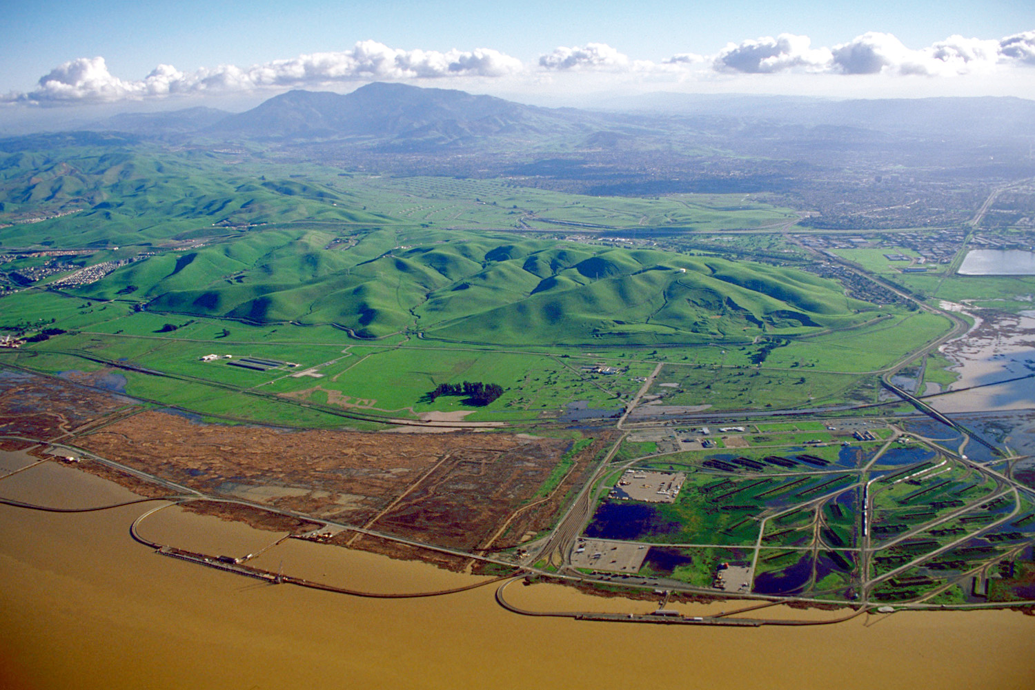
Archival aerial view toward Mount Diablo from Concord, with green hills and waterfront in the foreground.
Mount Diablo viewed from Concord. Archival image; date not recorded.Photo by U.S. Army Corps of EngineersPhoto sourcePublic domain (U.S. federal government work)
Illustration: a Mount Diablo fairy lantern, the nodding yellow globe lily, with its narrow leaves.
Mount Diablo fairy lanternA globe lily that grows almost nowhere but this mountain, best known along the Mitchell Canyon Trail. It blooms late March–mid June, as MDIA and CNPS describe it.

What we still want to learn from locals

  • Which access point suits a first visit with kids?
  • How early does Mitchell Canyon fill on a spring weekend?

Make a day of it

Nearby stops, with straight-line distances. Check routes and hours before you go. Nothing is booked here.

  • Eat & Drink

    Coffee or breakfast · 1.4 mi away, straight-line from Mitchell Canyon Staging Area

    Ñ (Enye) Latin Table

    Latin American dinner on Oak Street, with weekend brunch and online table booking.

    Dinner daily, 4:00 to 9:00 pm · Brunch Saturday and Sunday, 10:00 am to 2:00 pm

    Add to my day: Ñ (Enye) Latin Table
  • Eat & Drink

    Lunch or dinner · 1.4 mi away, straight-line from Mitchell Canyon Staging Area

    Vinny's Taqueria

    A downtown taqueria and tequila bar serving tacos, fajitas and enchiladas, with online ordering.

    Monday to Thursday, 11:00 am to 8:00 pm · Friday and Saturday, 11:00 am to 9:00 pm · Sunday, 11:00 am to 8:00 pm

    Add to my day: Vinny's Taqueria

Put a whole day together, one step at a time: Build your day

Sources and checks